


King Voting District, Johnson County, Arkansas
About
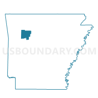
Outline

Summary
| Unique Area Identifier | 527000 |
| Name | King Voting District |
| County | Johnson County |
| State | Arkansas |
| Area (square miles) | 24.78 |
| Land Area (square miles) | 24.64 |
| Water Area (square miles) | 0.14 |
| % of Land Area | 99.43 |
| % of Water Area | 0.57 |
| Latitude of the Internal Point | 35.53686540 |
| Longtitude of the Internal Point | -93.51160530 |
Maps


Graphs
Select a template below for downloading or customizing gragh for King Voting District, Johnson County, Arkansas


Neighbors
Neighoring Voting District (by Name) Neighboring Voting District on the Map
- Horsehead Voting District, Johnson County, AR
- Low Gap Voting District, Johnson County, AR
- Red Lick Voting District, Johnson County, AR
- Spadra Ward 3, Johnson County, AR
- Spadra Ward 4, Johnson County, AR
Top 10 Neighboring County Subdivision (by Population) Neighboring County Subdivision on the Map
- Spadra township, Johnson County, AR (11,389)
- Red Lick township, Johnson County, AR (1,232)
- King township, Johnson County, AR (1,227)
- Horsehead township, Johnson County, AR (761)
- Low Gap township, Johnson County, AR (136)
Top 10 Neighboring Unified School District (by Population) Neighboring Unified School District on the Map
- Clarksville School District, AR (14,088)
- Lamar School District, AR (6,860)
- Jasper School District, AR (5,912)
Top 10 Neighboring State Legislative District Lower Chamber (by Population) Neighboring State Legislative District Lower Chamber on the Map
Top 10 Neighboring State Legislative District Upper Chamber (by Population) Neighboring State Legislative District Upper Chamber on the Map
Top 10 Neighboring 111th Congressional District (by Population) Neighboring 111th Congressional District on the Map
Top 10 Neighboring Census Tract (by Population) Neighboring Census Tract on the Map
- Census Tract 9518, Johnson County, AR (4,669)
- Census Tract 9517, Johnson County, AR (4,452)
- Census Tract 9519, Johnson County, AR (3,560)